Profile Equipment
High-tech
TrekAce® · Navigation and command by touch

Know where you are without GPS. Know what to do without looking.

Non-GNSS positioning and a haptic sleeve that turns information into touch.

In a contested environment the two things a soldier relies on most are the first to go: GPS is jammed or spoofed, and the radio net is full. What is left is a screen he cannot afford to look at and a voice he cannot hear.

TrekAce takes a different route. Its software keeps an accurate position without any satellite signal, and its wearable sleeve delivers direction, alerts and commands through the one sense that is still free: touch. Eyes stay up and hands stay on the weapon.

Request a TrekAce demonstration
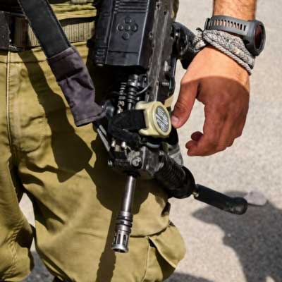
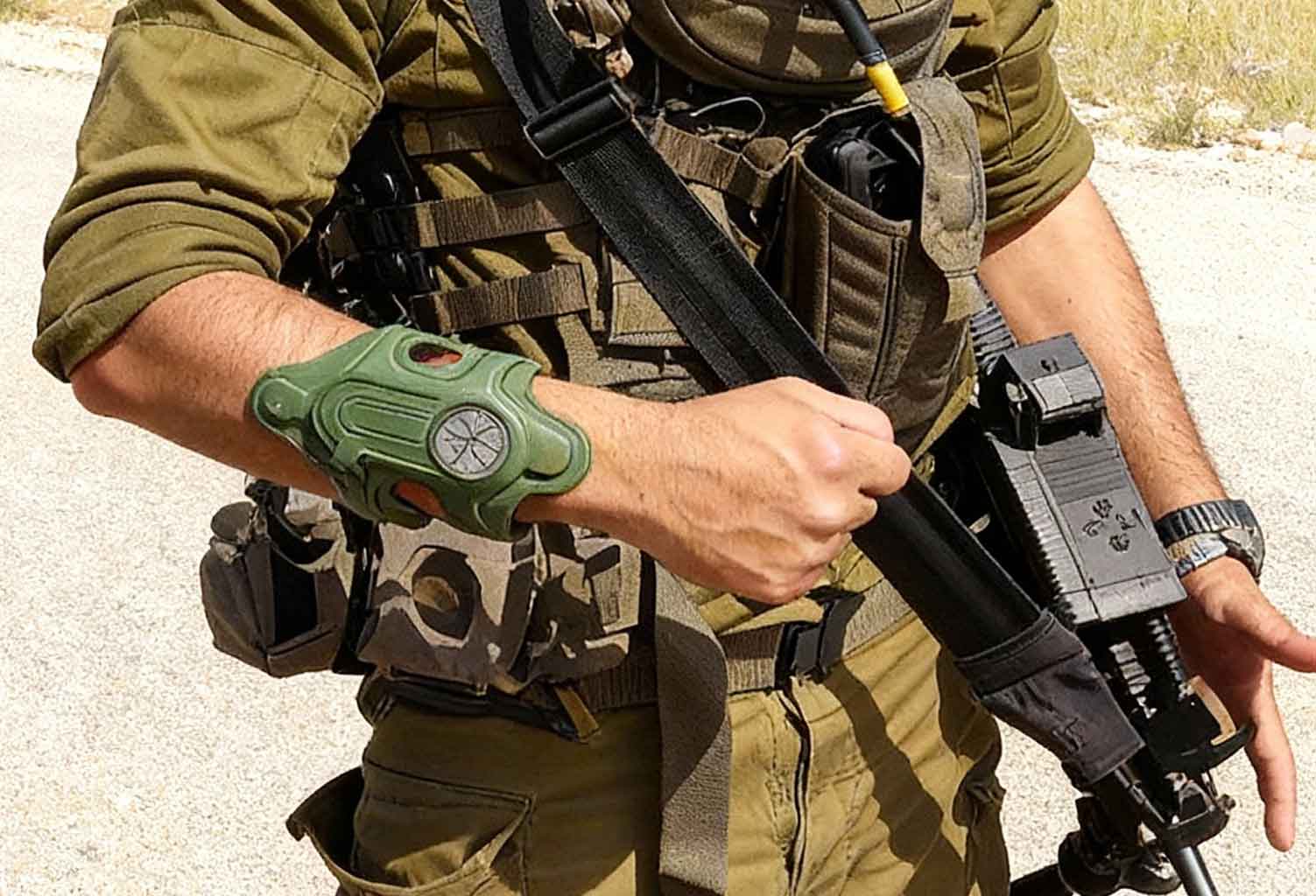
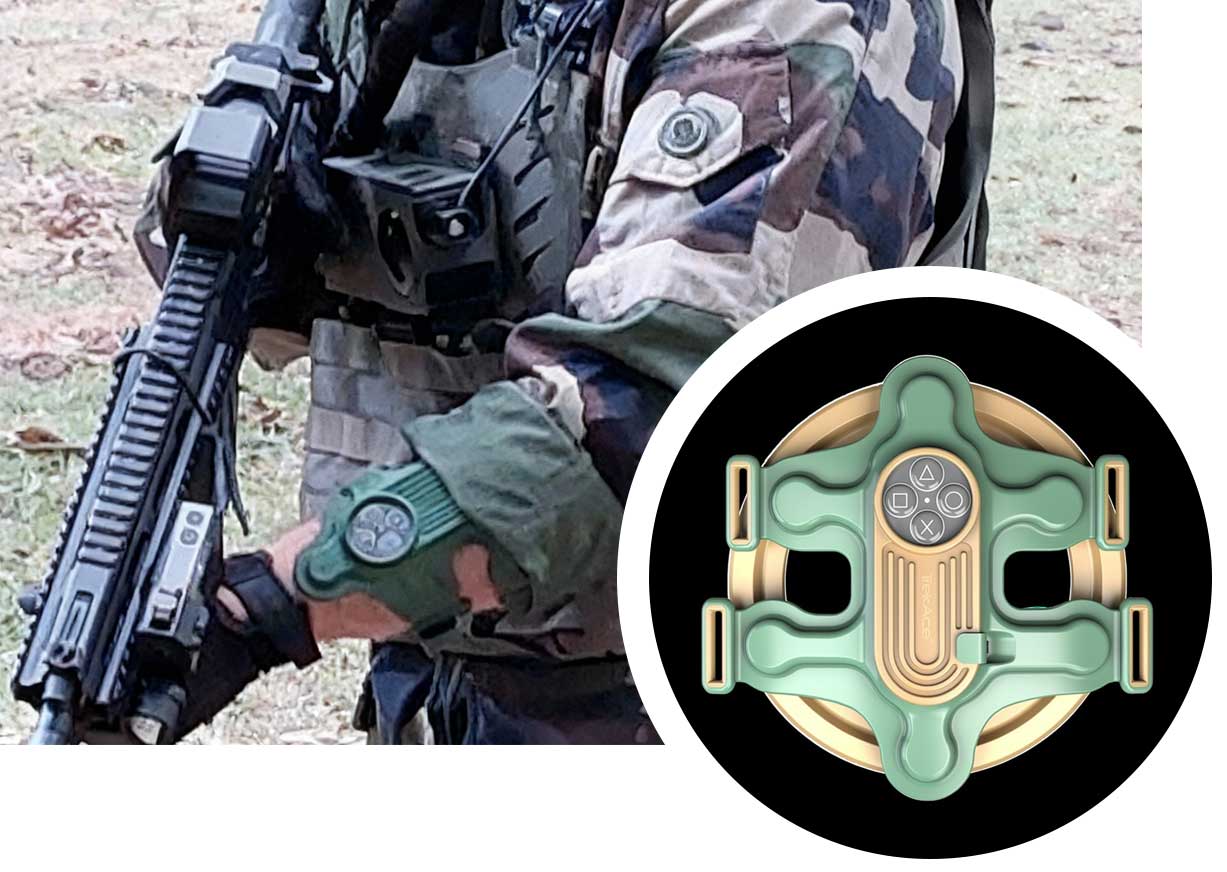
Soldier wearing the TrekAce CORE haptic sleeve on the forearm while holding a rifle
75%
shorter response time than visual signals, over
TRL 9
non-GNSS positioning: tested, field-ready and operational
3 min
one-time personal profile, then it knows how you walk
1 week
of operation on a 3-hour charge (CORE sleeve)
IP67
rated sleeve, charged over USB Type-C
1,000+
contestants beaten in the 2018 urban navigation challenge
The problem

Three human limits, and stress makes each one worse.

Navigation is not natural to people. It takes training, technique and technology, and when GPS disappears most are simply lost. Hearing has its own limit: the brain cannot follow two spoken instructions at once, so commands overlap and get missed. And sight is already busy: nobody processes movement and visual instructions at the same time without slowing down.

Smart goggles, head-up displays and extra screens add to that load instead of taking it away. Under fire, with noise, fatigue and adrenaline, the result is slower reactions and mistakes that matter.

  • Without GPS, navigation fails.
  • Voice commands overlap and get lost.
  • Visual information competes with the task of moving and fighting.
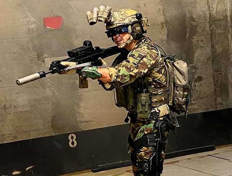
Operator in the aiming position wearing goggles, with the haptic sleeve on the forearm
Non-GNSS positioning

Position and navigation from the phone you already carry.

The positioning solution is software only: an Android application, or an algorithm library built into your own navigation app or battle management system. It takes the raw data from the sensors in a standard Android device, or from an IMU, and a proprietary machine-learning algorithm turns those imprecise measurements into an accurate position.

The key is a personal profile. The system learns how one person moves, the stride, the posture, the tilt, and uses that to predict every step. No extra hardware, no beacons, no Wi-Fi and no satellite signal. It keeps working when GNSS is unavailable, denied, jammed or spoofed, and it can keep feeding a C4I or BMS system so blue-force tracking does not go blind.

  • Software only: Android app or algorithm library.
  • Works with legacy Android devices, including ATAK set-ups.
  • Feeds C4I/BMS for blue-force management without GNSS.
  • Patented, and at TRL 9.
CORE

A robotic sleeve that speaks in touch.

CORE is a patented wearable sleeve for the forearm. It translates what would normally be a screen or a voice into a tactile language: a direction to walk, an alert from a sensor, a command from the team leader. Touch is an unused channel, it is intuitive, and it needs no cognitive processing, so the message arrives without taking attention from anything else.

The vocabulary is wide enough for real use: directional guidance from navigation apps, alerts from sensors, and notifications and tactical commands from a battle management system.

  • IP67 rated; light, ergonomic and low-profile.
  • A 3-hour charge over USB Type-C gives a full week of operation.
  • Takes input from navigation apps, sensors and BMS.
TrekAce CORE sleeve worn on the forearm, with a close-up of the haptic unit
How positioning works

Three minutes once. Then it works wherever you walk.

  1. 1

    Personalise

    The user creates a profile in a single three-minute process. It is done once, and it lets the algorithm learn that person's walking pattern.

  2. 2

    Operate

    Use the TrekAce navigation app, or build the algorithm library into a third-party app or a C4I/BMS system, and keep an accurate position when GNSS is gone.

  3. 3

    Feel the way

    With the CORE sleeve the route arrives as touch on the forearm. No screen to check, no voice in the headset.

The system

Layers that work alone or together.

Start with positioning, add the sleeve, then the command applications. Each layer solves a problem of its own.

Non-GNSS PNT

Software-only positioning and navigation for the dismounted soldier, independent of satellites.

CORE

The haptic sleeve: receives navigation, alerts and commands as touch.

TAPPER

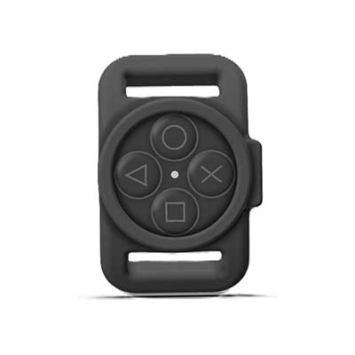
A gun-mounted controller with four game-controller style buttons. It is the talking side of the haptic conversation; CORE is the listening side.

LEADER

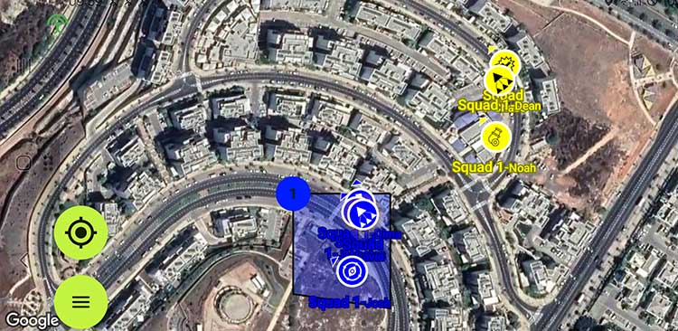
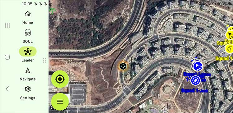
An Android command and control app for squad and team leaders: team positions including the floor in a building, where each operator is looking, planning and debrief tools, and silent haptic commands.

Lightsaber

Shared situational awareness for the team. Position, bearing and a rangefinder combine into target coordinates, so a teammate can be pointed to a target without words or gestures.

Proven

Measured, awarded and in use.

Performance

Touch is faster than sight.

“They're not just the best. Operationally, they're the only ones”

— Defence industry leader from a NATO country, quoted by TrekAce

In the supplier's comparison of tactile signals against hand signals, tactile commands cut response time by more than 75% compared with visual signals, and improved the scores for situational awareness, execution and workload.

75%+
shorter response time than visual signals
Dozens
of granted patents worldwide
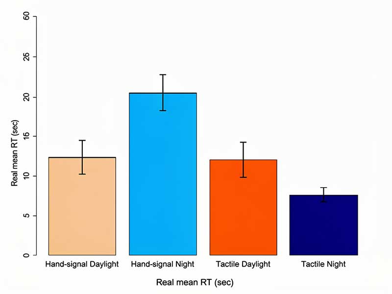
Bar chart of mean response time for hand signals and tactile signals, by day and by night
Mean response time: hand signals against tactile signals, day and night (supplier data).
Award

Winner of the 2018 urban navigation challenge.

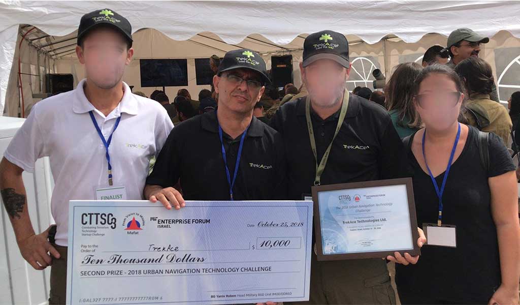
The positioning technology won the 2018 US Department of Defense and Israel Ministry of Defense Urban Navigation Challenge for navigation in GPS-denied environments, against more than 1,000 international contestants.

Since then it has been fielded with special operations and infantry units in several countries. TrekAce describes it as war proven.

2018
US DoD and Israel MOD Urban Navigation Challenge
1,000+
international contestants
The TrekAce team receiving the award at the 2018 urban navigation challenge
Command and control

The team leader sees the team. The team feels the command.

LEADER shows every operator on the map, GPS or not, and sends commands that arrive as touch. TAPPER lets an operator answer without taking a hand off the weapon.

TrekAce LEADER map view with team members and a marked zone
LEADER: team positions, headings and a safe zone on the map.
TrekAce LEADER application menu beside the map
One app for maps, communication, planning and 2D/3D location awareness.
TrekAce TAPPER controller mounted on a rifle
TAPPER on the weapon: commands under the thumb.
TrekAce TAPPER controller with four buttons
Four buttons, each mapped to a predefined tactical function.
See it work

TrekAce in use.

Footage from the developer.

TrekAce: hands-free, intuitive navigation.
TAPPER and CORE: sending and receiving commands by touch.
FAQ

Questions we get asked.

Does it need extra hardware to work without GPS?

No. The positioning is software on a standard Android device, or on an IMU. It needs no nodes, no beacons, no Wi-Fi and no satellite signal. The CORE sleeve and the TAPPER controller are optional layers on top.

How does it know where I am without satellites?

It learns how you move. A one-time, three-minute personalisation records your walking pattern, and a machine-learning algorithm uses that with the device's own sensors to track your position step by step.

Can it work with our existing battle management system?

Yes. The algorithm library can be integrated into a third-party navigation app or a C4I/BMS system, and LEADER offers an SDK for integration with existing command and control systems.

Why touch instead of a display?

Because sight and hearing are already overloaded in a fight. A signal on the forearm is understood without looking and without listening, and according to the supplier it is acted on more than 75% faster than a visual one.

Who supplies TrekAce in the Netherlands?

Profile Equipment is TrekAce's reseller for the Netherlands. We arrange demonstrations and trials and support integration with your equipment.

Take the screen out of the fight.

Tell us how your teams navigate and communicate today. We arrange a demonstration of the positioning and the sleeve.

Request a TrekAce demonstration